PCR-GLOBWB 2.0
PCRaster GLOBal Water Balance model: version 2.0


Website: PCR-GLOBWB model documentation (pcrglobwb.readthedocs.io)
Paper about the complete model: Sutanudjaja et al (2018).
Additional specific documentation: Wada et al. (2014) (Hydrology and water Use), Wada et al. (2015) (water use),Van Beek et al. (2012) (water temperature), De Graaf et al (2015) (Global groundwater), Sutanudjaja et al. (2014) (full coupling PCR-GLOBWB-MODFLOW)
Download:
PCR-GLOBWB 2.0 is available from the following public repository:
https://github.com/UU-Hydro/PCR-GLOBWB_model
For example input and parameter files and configuration files (Rhine catchment) we refer to:
https://github.com/UU-Hydro/PCR-GLOBWB_input_example
Global input data can be downloaded from:
https://zenodo.org/record/1045339#.XWUr7E2P5aR
We are working on a model launcher using docker technology (forthcoming)
Description:
PCR-GLOBWB 2 is a grid-based global hydrology and water resources model devloped at Utrecht University. The computational grid has a 5 arc-minute resolution (~10 km at the equator) and covers all continents except Greenland and Antarctica. Time steps for hydrology and water use are one-day, while the internal time stepping for hydrodynamic river routing is variable. For each grid cell and each time step, PCR-GLOBWB 2 simulates moisture storage as well as the water exchange between the soil, atmosphere and underlying groundwater reservoir. The exchange with the atmosphere comprises precipitation, evaporation from open water, snow and soils and plant transpiration, while the model also simulates snow accumulation, snowmelt, and glacier melt. PCR-GLOBWB simulates runoff partitioned into surface runoff, interflow, and groundwater recharge as well as routing of water over the terrain. Runoff generated by snow and glacier melt, surface runoff, interflow, and groundwater is routed across the river network to the ocean or endorheic lakes and wetlands using the kinematic wave approximation. It also possible to include floodplain inundation and to simulate surface-water temperature. PCR-GLOBWB 2 includes over 6000 manmade reservoirs from the GranD database that are progressively introduced in time and a reservoir operation scheme dependent on each reservoir’s purpose. Human water use is fully integrated with the hydrological model. Thus, at each time step: 1) water demand is estimated for irrigation, livestock, industry, and households; 2) these demands are translated into actual withdrawals from groundwater and surface water (rivers, lakes, and reservoirs) subject to availability of these resources and maximum groundwater pumping capacity in place; and 3) consumptive water use and return flows are calculated per sector. As an option PCR-GLOBWB 2 can be partially or fully coupled to a 2-layer global groundwater model based on MODFLOW and to the hydrodynamic model codes DFLOW-FM, CaMaFlood and LISFLOOD-FP.
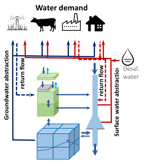
Schematic of PCR-GLOBWB 2 cell with its functionality
NEW: a nice movie with output from PCR-GLOWB 2.0 : 30 years of simulation at 5 minute resolution and daily time step. Shown are monthly averages of 1) upper left: soil moisture (0-30 cm); upper right: discharge (m3/s), lower left: snow cover fraction; lower right: : soil moisture (0-30 cm). This movie was rendered at the eScienceCenter in the project eWaterCycle.
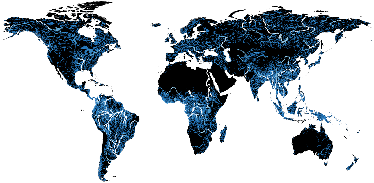
Average runoff at 5 arc-minues from PCR-GLOBWB
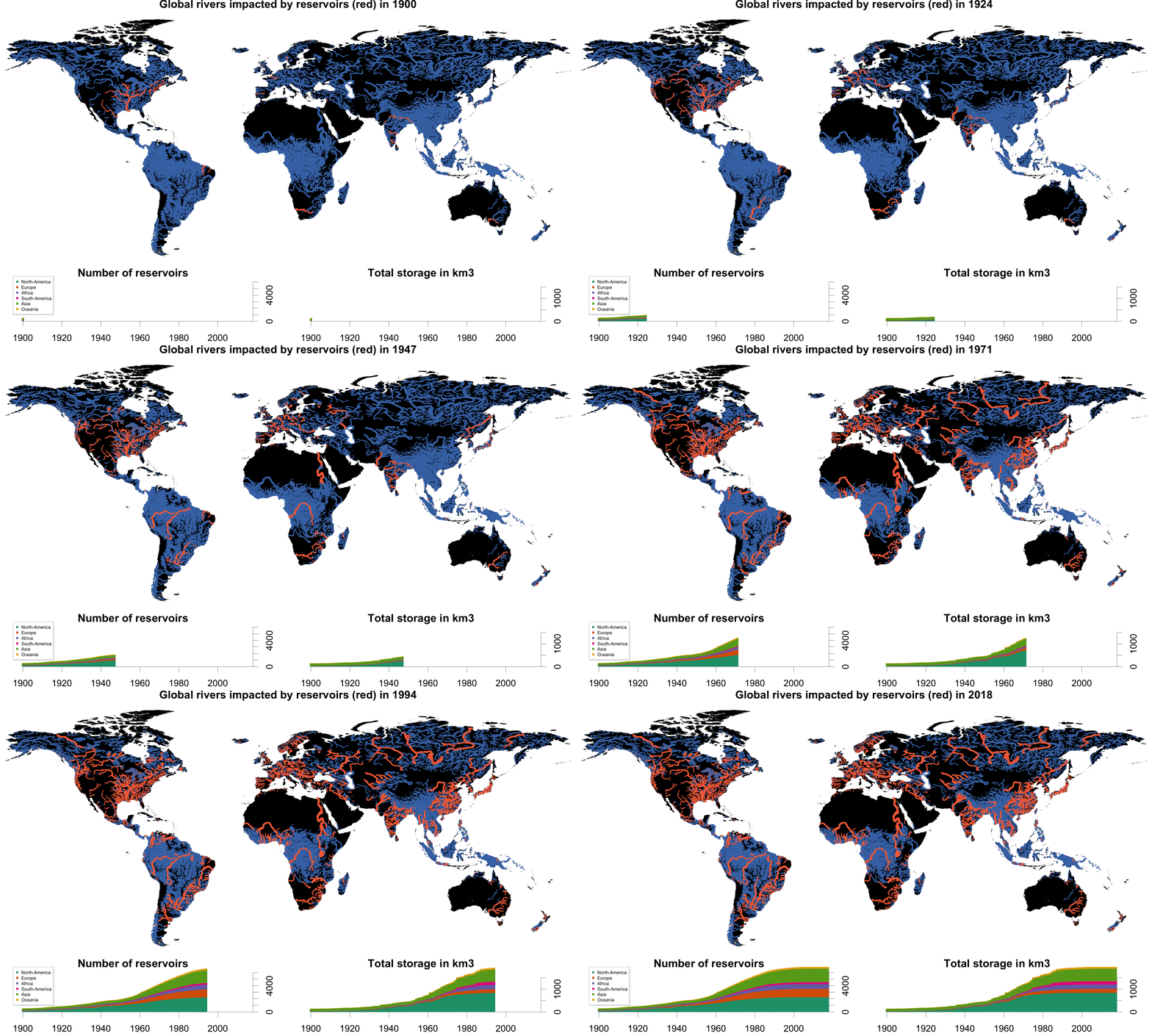
Dams and reservoirs are inserted dynamically over time in PCR-GLOBWB 2 simulations. A simple reservoir regulation scheme depending on the reservoirs’ main purpose is implemented. The dams are from the GranD database. The animated GIF shows how the global river are becoming more and more regulated by dams over time. The lower figures show the number of reservoirs in time and their volume in km3.
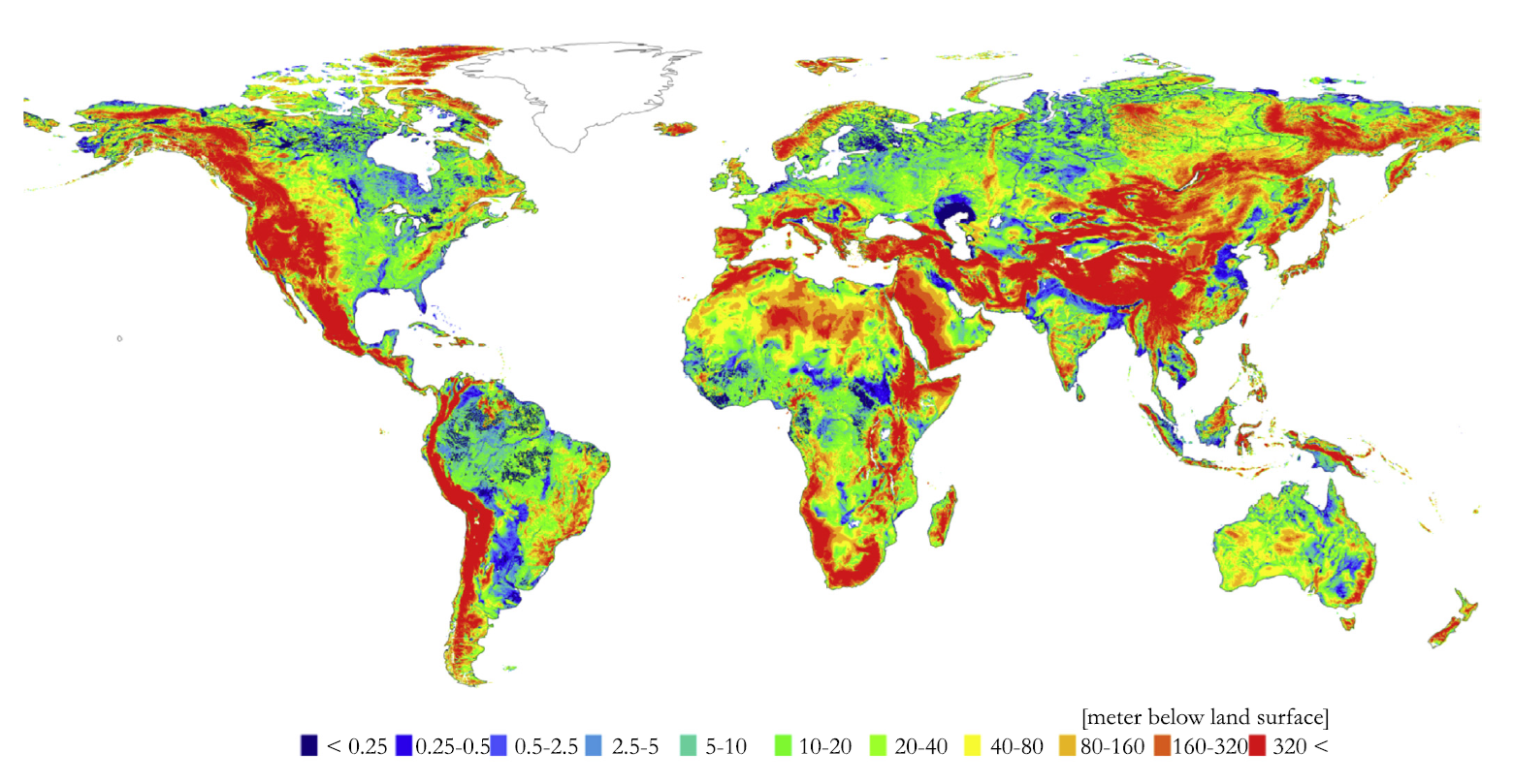
Groundwater heads calculated with a global-scale two-layer 5 arc-minutes transient groundwater model based on MODFLOW. The groundwater model can be coupled with PCR-GLOBWB (one way and two way). Here, groundwater withdrawal, surface water levels and diffuse recharge/capillary rise are calculated with PCR-GLOBWB and groundwater heads and groundwater fluxes to-from surface water by MODFLOW (with drains to parameterize the smaller non-resolved streams and springs) (Source: De Graaf et al. 2017. A global-scale two-layer transient groundwater model: Development and application to groundwater depletion. Advances in Water Resources 102, 53-67)
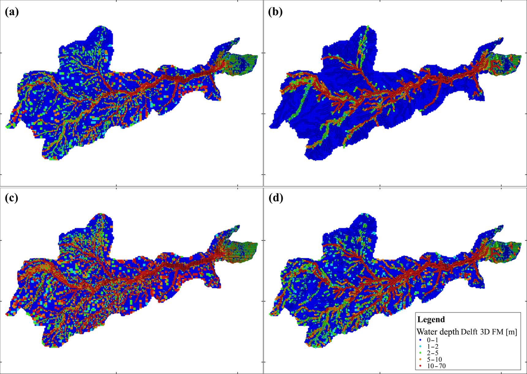
Example of PCR-GLOBWB coupled to a 2D-hydrodynamic model (DFLOW-FM) over the Amazon river basin solving the 1D and 2D shallow water equatioins. This enables modelling overbank inundation including backwater effects; a) 2D hydrodynamic modelling using GRDC discharge obsrevations as boundary conditions; b) 1D/2D hydrodynamic modelling (main channel dimensions prescribed and modeled by 1D-hydrodynamics); c) 2D hydrodynamics coupled with PCR-GLOBWB ; d) 1D/2D hydrodynamics coupled with PCR-GLOBWB. The coupling is done using the open-source coupling software tool Glofrim on github (https://github.com/openearth/glofrim) that also allows coupling with Lisflood-FP and CaMaFlood (source: Hoch, J. M., Haag, A. V., van Dam, A., Winsemius, H. C., van Beek, L. P. H., and Bierkens, M. F. P., 2019. Assessing the impact of hydrodynamics on large-scale flood wave propagation – a case study for the Amazon Basin. Hydrol. Earth Syst. Sci., 21, 117-132).
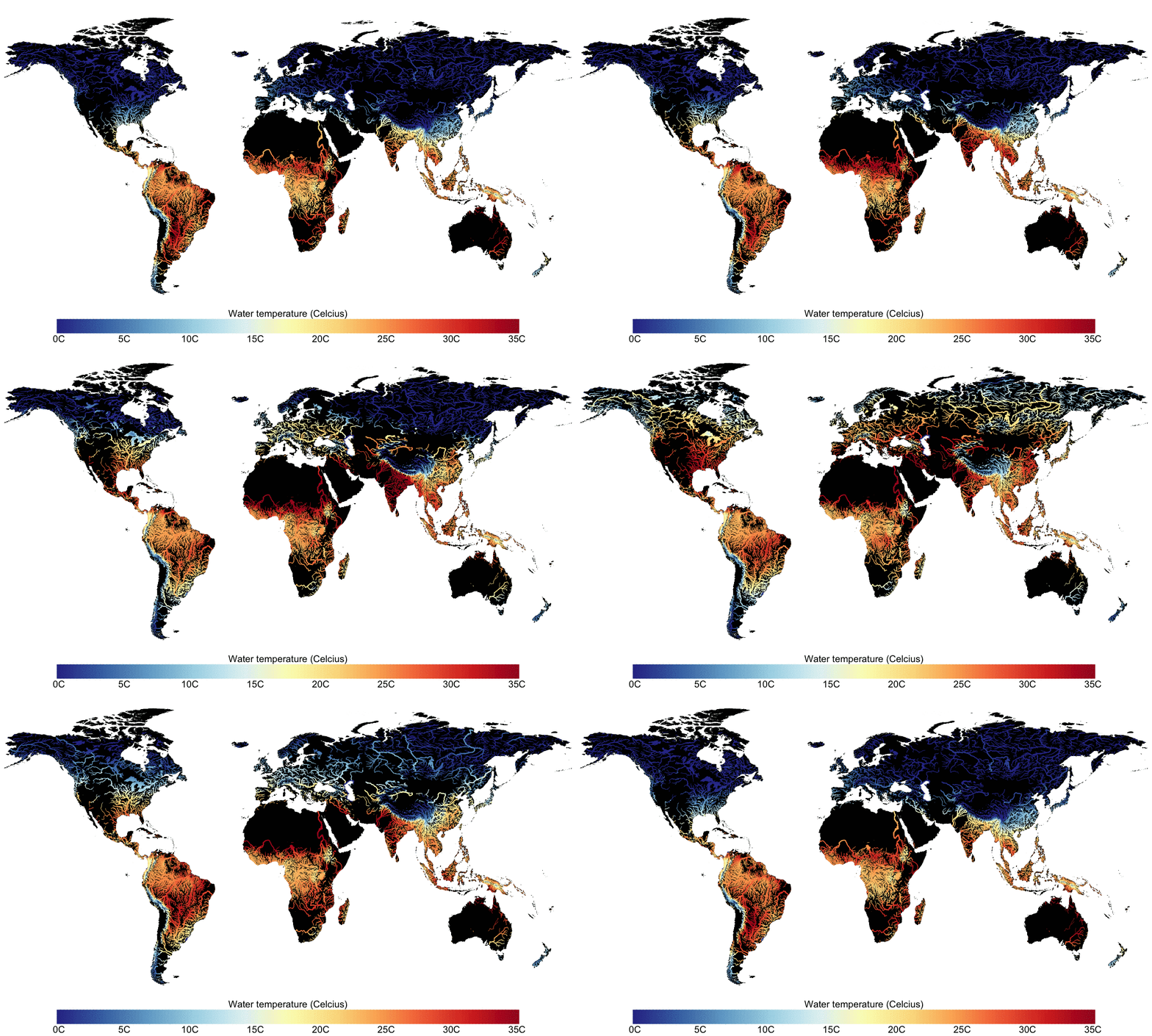
Yearly water temperature climatology based on 30 years of water temperature simulations with DynWat. Dynwat calculates daily surface water temperature by solving the energy balance of flowing water including: the influx of water from precipitation, surface runoff, interflow and groundwater runoff; the surface energy balance (radiation and turbulent fluxes) and lateral transport by advection. It includes a routine to calculate overbank inundation (parameterzied) that increases the area of the surface watre bodies; ice formation, melt and break-up; and a routine to handle lakes and reservoirs where the energy balance is only resolved for the thermally active layer (epilimnion) as long as the temperature profile is stable. This layer is fully mixed over the lake or reservoir depth if the temperature of the epilimnion is low enough to cause instability. In the example shown here, DynWat is forced with runoff and river discharge from PCR-GLOBWB 2, but it can also be forced by the output of any other land surface model. The DynWat code is freely available from Github (https://github.com/wande001/dynWat) (source Wanders,N., van Vliet, M.T.H., Wada,Y.,Bierkens,M.F.P. and van Beek, L.P.H.(Rens), 2019. High-resolution global watertemperature modeling. Water Resources Research 55, 2760–2778).


